Breadcrumb

  1. Home
  2. Search Maps
  3. Map of the Occupation of Japan

Map of the Occupation of Japan

Map of the Occupation of Japan
Accession Number
M654
Cartographer
Army Map Service, U.S. Army, Washington, D.C. Reprinted by 69th Engineer Topographic Company, August 1945.
Photo Color
Color
Physical Size
28 1/4 X 34 1/4 inches
Restrictions
Unrestricted
Scale
1:250,000
TIF Identifier
M654.tif
Rights

This item is in the public domain and can be used freely without further permission.

Note: If you use this image, rights assessment and attribution are your responsibility.

Credit: Army Map Service, U.S. Army, Washington, D.C. Reprinted by 69th Engineer Topographic Company, August 1945.

Courtesy Harry S. Truman Library & Museum, Independence, Missouri.

Attention media: Please make note of this item's map number. Print out this page and retain it for your permissions records before downloading this image file for possible publication. Library staff cannot sign permissions forms or provide additional paperwork. The Library charges no usage fees for downloaded images. Fees are charged for higher resolution scans.

Description

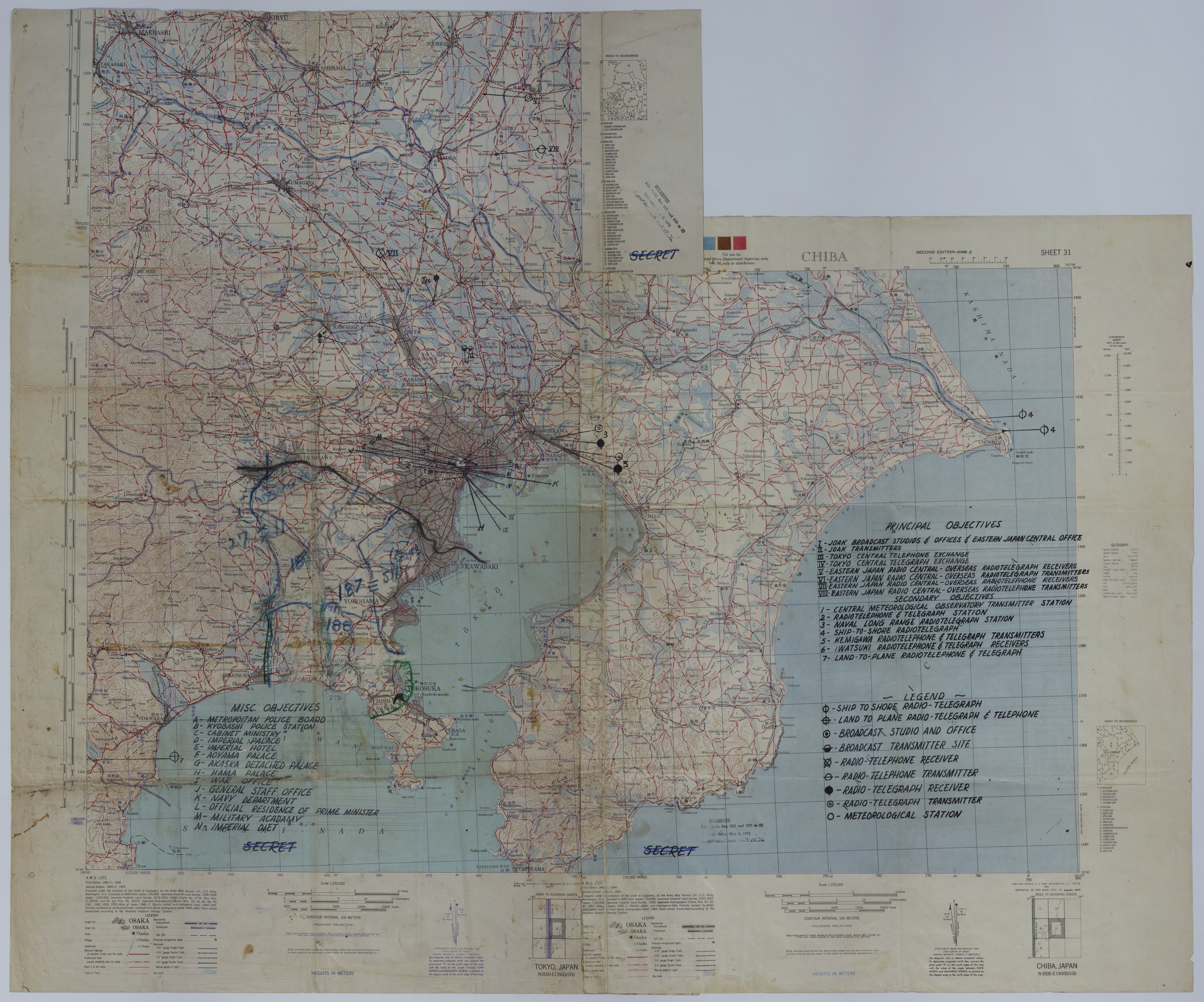
Portions of three American maps have been taped together to show the area surrounding Tokyo Bay. The map shows highways, roads, trails, boundaries, principal navigational lights, railroads, rice fields, relief, and other details. A meters to feet conversion graph, Japanese to English glossary, and index to boundaries are also included. Annotations in black pen highlight principal objectives, mostly that of communication centers, and miscellaneous objectives such as police stations, palaces, and military offices. Annotations, in blue, highlight the post-war occupation areas controlled by the 11th Airborne Division. The positions of 11th Airborne units, such as the 187th Glider Infantry Regiment, the 188th Glider Infantry Regiment, and the 511th Parachute Infantry Regiment, are included. In addition, the positions of the 27th Infantry Division, the 43rd Infantry Division, and the Americal Division (23rd Infantry Division) are marked. Handwriting on the back identifies this map as being part of the President's Secretary's Files. The handwriting reads: "Truman Papers-PSF, Misc. File."

Date(s)
ca.